Saturday, June 25, 2016

Hike #4: Ridge Trail to Leif Erikson to Tolinda Trail

Another hike! I'm slowly chipping away at those 80 miles of trails. Today's hike began with a walk across the St. John's Bridge to the west side, and then I headed up the Ridge Trail, which I had experienced on a previous hike a few weeks ago.


St. John's Bridge from the Ridge Trail

This connected me to Leif Erikons Drive. where I turned right and headed north.


While walking along Leif Erikson, I came across the remains of an old house or other structure. I sat on the steps and enjoyed a quick lunch break.


Then I continued on until I reached the Tolinda Trail, which took me south down the hills to Germantown Road.


Walking along the side of Germantown Road was, quite frankly, terrifying. There's not much room (in some places, none at all) for a pedestrian to walk along the side of the road. Thankfully, I only had to walk about 1/4 of a mile to get back to the frontage road for the St. John's Bridge, where there's a sidewalk. Then I walked back across the bridge, got on the bus, and headed home.

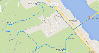
Below is the Google Maps version of my hike:


However, there are two trails that connect from the frontage road to the Ridge Trail, and Google Maps does not recognize the one I took. So below, you can see the trail I took marked with a blue marker.


If my calculations are correct, I have hiked about 13.5 miles of the trail system so far. Woot!

Sunday, June 19, 2016

Hike #3: Wildwood to Waterline to Leif Erikson to Cannon Trail

Today was an eventful day! First, I attended the Portland Pride Parade with a variety of friends, new and old. It was a beautiful day for a parade, and it was great to see so many people in attendance, showing their support for the LGBTQ community.


After the parade, I headed out to Forest Park to get my hike on. I started from the Wildwood Trail just off Germantown Road (which is a lovely, winding road). The sunlight coming through the canopy was simply spectacular.


I came to the junction with the Waterline Trail and then took a left. I walked down this trail for a bit until it met up with Leif Erikson Dr, where I took another left.


This takes you to the very end of the Leif Erikson trail, which deposits you into a parking lot. From there, I found the Cannon Trail, which took me all the way back to the Wildwood Trailhead.


I took many pictures of slugs, of course...


And also some various fungi, including Indian Pipe (the white fungus).


According to Google Maps, I hiked 2.3 miles. Not bad for a quick, Sunday afternoon hike!


Monday, June 6, 2016

Hike #2: Ridge Trail to Leif Erikson Dr to Firelane 7A

Today I completed my second hike for the All Trails Challenge, and this time, I decided to head a little further north. I rode the bus out to St. Johns, walked across the St. Johns Bridge, and then began my journey.

Walking across the bridge.
Just a short way up the Ridge Trail, you get a great view of the St. Johns Bridge and the mountains. I was able to see Mt. Adams, Mt. St. Helens, and even the top of Mt. Rainier.


There's a good bit of elevation gain from the St. John's Bridge to the junction with Leif Erikson Dr, but once you're on Leif Erikson, the trail becomes very flat and easy.


This is where my plans went awry. I had planned to walk the Leif Erikson trail for only .6 miles and then turn left onto a unnamed trail on my Forest Park map. The first mile marker I saw was for 8 1/4 mile, so when I saw a mile marker sign for 7 1/4 mile, I realized I had gone too far and had to turn around. Using Google Maps did not really help, as the trail I wanted to take was not marked on Google Maps. I back-tracked to where I thought the trail might be, and after searching around a bit, I finally located it through the brush. It's unmarked, which is why I missed it the first time around.

Can YOU spot the trail?
It was a pretty steep scramble down the hill via this narrow trail, which eventually started running along a wire fence. While walking this part of the trail, I saw this interesting sign:


I also came across some sort of concrete structure covered in graffiti, with a pink Minnie Mouse blanket lying on the ground.


It was only when I got to the end of the trail that I learned the name of the trail: Firelane 7A.


I then walked up the ramp and back over the St. John's Bridge to conclude my journey. Since Google Maps does not recognize the Firelane 7A trail, I cannot use that to map my route. So instead, I highlighted my route on my Forest Park map with a magenta marker:


If I wasn't recovering from being sick for a week, I probably would have attempted to do more. But still, it was fun, as these were all trails that I had never seen before. To close, here are some Tiger Lillies I saw on the trail: